
COMPLETE STREETS
Advancing Complete Streets for the Santa Fe Metropolitan Area.
Complete streets are streets for everyone
Complete Streets are an approach that integrate people and place in the planning, design, construction, operation, and maintenance of transportation networks. In 2022, the Santa Fe MPO Transportation Policy Board, the City of Santa Fe, and Santa Fe County all adopted updated complete streets resolutions.
To illustrate the concept of Complete Streets as they could be applied in Santa Fe, the MPO partnered with the American Heart Association to create a series of graphic renderings. These renderings are not meant to represent a proposed design for any specific location.
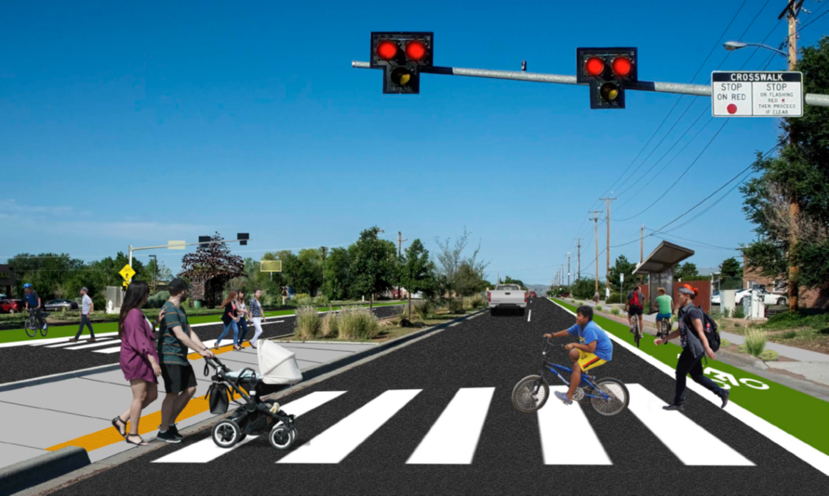
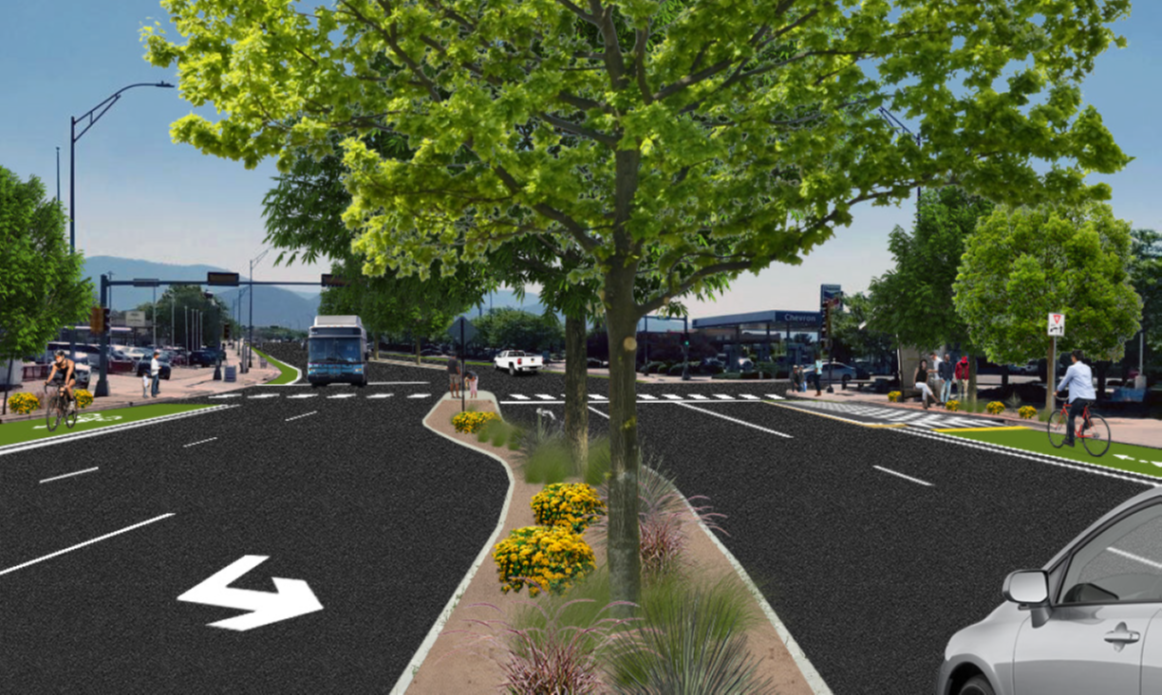
EXAMPLE 1: Airport Rd. near S. Meadows Rd. and Country Club Gardens
CITY COUNCIL DISTRICT 3
COUNTY COMMISSION DISTRICTS 2 + 3
PLANNING DOCUMENTATION
Observations And Recommendations: The Built Environment Santa Fe, New Mexico
Pedestrian Priorities: Santa Fe MPO 2020-2045 Metropolitan Transportation Plan
The Airport Road corridor was selected by New Mexico MainStreet in July 2021 to participate in the Urban Neighborhood Commercial Corridor (UNCC) pilot program. The Airport Road Overlay District was adopted in 2012 with the purpose and intent of:
• Establish an attractive, street-oriented character
• Create a unique sense of place and identity
• Promote a healthy and safe environment through the development of walkable neighborhoods, less dependence on the automobile
KEY ELEMENTS/ISSUES:
• Unsafe speeds with moderate traffic volumes
• Road acts as a barrier between multiple schools, businesses, and neighborhoods
• Lane widths and roadway configurations contributes to speeding
• Very long distances between signalized intersections encourage unsafe mid-block pedestrian crossings
• Santa Fe Public Schools identifies the Country Club Gardens and surrounding neighborhoods area as “Hazardous Zones” within walking distance of Sweeney Elementary. The result is short bus trips across Airport Road.
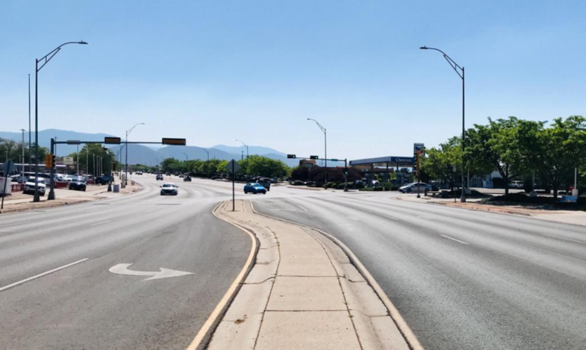
• Average Daily Traffic volumes have been steady over the past six years with approximately 22,000 vehicles split east and west each day. Traffic volumes on the corridor between NM 599 and South Meadows Road are within the criteria for a lane reduction or road diet. A study is recommended to detail the impacts.
There have been 546 crashes between Buffalo Grass Rd. and Jemez Rd. between 2010 and 2020, 5 involving pedestrians and 7 involving bicyclists.
One was fatal and 190 were injurious. Of these, 90 crashes occurred within 30 m of Airport Road and Country Club Gardens between 2010 and 2020.
One was a fatal vehicle crash and 3 involved pedestrians, 2 of whom were injured.
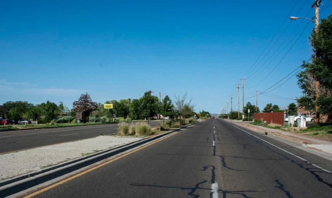
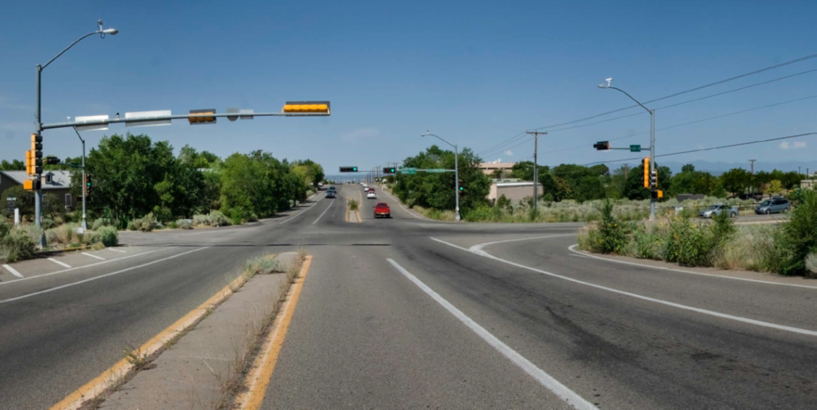
BEFORE: No mid-block crossings with unreasonably long distances between intersections. Unnecessarily wide lane widths promote speeds above posted limit of 45 MPH. Posted speed limit is the result of intended existing design and is exceptionally high and unsafe for the neighborhood corridor. It is recommended that the design of the roadway facilitate a 35 MPH posted speed limit. The artistic bus stop provides shelter on the south side, but no shelter exists on the north side. Narrow sidewalks do not promote family walking trips. The 5’ bike lane shares the gutter space rendering the ridable area less than 4’ and closer to traffic. The bike lanes are highly uncomfortable, resulting in minimal use.
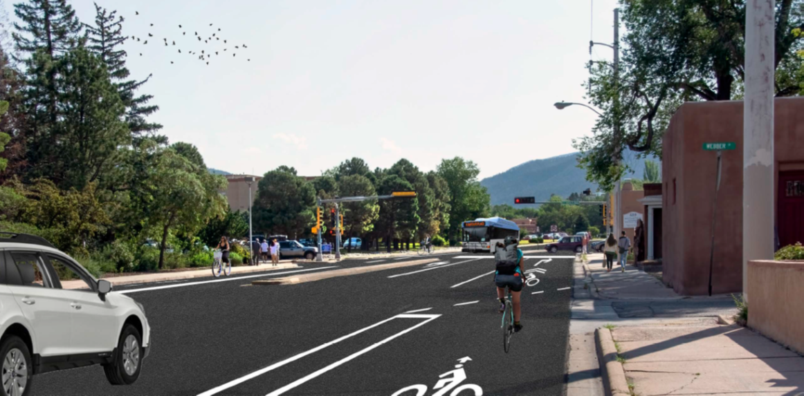
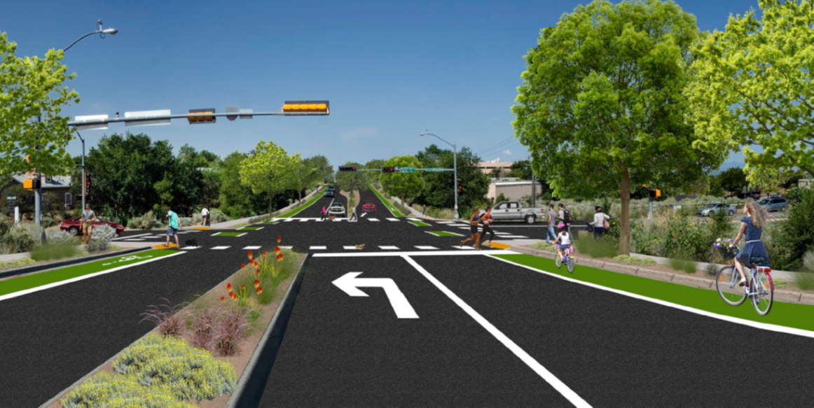
AFTER: Mid-block Pedestrian Hybrid Beacon (PHB) with wide continental striping, median refuge and off center design to encourage pedestrians to face on-coming traffic for greater safety. The installation of a PHB can reduce pedestrian crashes by 55%. (NCHRP Research Report 841) 6’ wide bike lane with continuous green painting and wide width buffer stripe provides motorists with a significant visual cue while increasing the comfort level of bicyclists. Lane width reductions to maximum 10’ has the effect to reduce vehicle speeds. Covered ADA accessible bus stops encourage ridership.
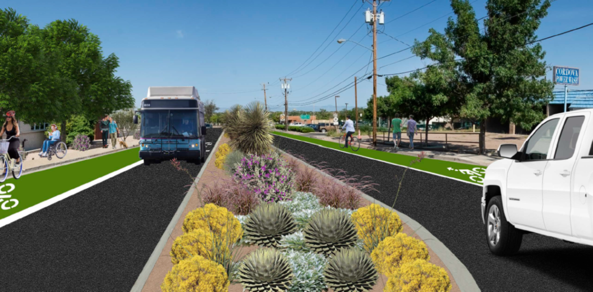
EXAMPLE 2: W Cordova Rd. between Cerrillos Rd. and Railroad Tracks
CITY COUNCIL DISTRICT 2
COUNTY COMMISSION DISTRICT 4
PLANNING DOCUMENTATION
Observations and Recommendations: The Built Environment Santa Fe, New Mexico
There have been a total of 417 crashes on Cordova between Cerillos and St Francis from 2010 through 2020 , including these major intersections. 7 of these crashes involved pedestrians and 5 involved bicyclists, with 11 of these 12 crashes resulting in an injury. 110 recorded crashes within 30 m of W. Cordova and Cerrillos, 25 at the Rail Trail Crossing, and 282 at the intersection with St. Francis.
KEY ELEMENTS/ISSUES:
• Rail Runner Train Transit stop, Santa Fe Trails Bus Transfer Station and NCRTD Bus Stops Transit and Rail Trail Crossing
• Unnecessarily wide travel lanes and width with low traffic volumes
• Road acts as a barrier between significant employment centers, commercial retail uses and multi-family residential
• Roadway configurations contribute to speeding; very long distances between trail crossing and signalized intersections encourage unsafe mid-block pedestrian crossings
• Feeder to adjacent Capital Station Transit Center.
• Average Daily Traffic volumes have been steady over the past six years with approximately 10,000 vehicles split east and west each day. Traffic volumes are ideal for a lane reduction or road diet. The redesign of Cerrillos Road including the W. Cordova intersection also supports a lane reduction improving safe passage for all uses at this location.

BEFORE: Unnecessarily wide lane widths promote speeds above posted limit of 30 MPH. Having 4 travel lanes contributes to a difficult and long pedestrian trail crossing distance, currently unsignalized. It is recommended that the design of the roadway facilitate a 25mph posted speed limit. Existing sidewalks on north side have a narrow back of curb. The absence of bike lanes discourages bicycle travel and results in bicycle/pedestrian mixing on narrow sidewalks. The wide 14’ center lane expanse encourages speeding with minimal benefit to turning movements.
AFTER: The lane reduction will easily accommodate the low volume road and public transit, increase safety and encourage all mode trips in an area replete with public transportation options. The replacement of the wide 14’ center lane with a raised median with low water vegetation serves as a nice buffer between traffic. The addition of street trees, 6’ bike lanes, and wider sidewalks all serves to increase safety, encourage walking and bicycling, and helps create a distinct and attractive sense of place.
EXAMPLE 3: Paseo de Peralta at Old Santa Fe Trail
COUNCIL DISTRICT 2
COUNTY COMMISSION DISTRICT 1
PLANNING DOCUMENTATION
On-Street Bicycle Priorities: Santa Fe MPO 2020-2045 Metropolitan Transportation Plan 2019 Santa Fe Metropolitan Bicycle Master Plan
There have been 106 recorded crashes within 30 m of this intersection between 2010 and 2020. 31 of these have been classified as an Injury Crash, including 2 with pedestrians and one with a bicyclist. These 106 crashes are among the 193 crashes that have occurred in between Galisteo and Halona St. in the same time period.
KEY ELEMENTS/ISSUES:
• Paseo de Peralta, Santa Fe’s downtown beltway, was designed to facilitate traffic movements around the core of downtown in the 1950s and bisects some of the most heavily traveled pedestrian intersections in the City. Key pedestrian generators include the State Capitol, commercial centers, and the entrance to Canyon Road.
• Sharp curves in the road reduce sight lines and make uncontrolled mid-block crossings more dangerous.
• Posted speed limit is 25 MPH. Design of roadway and wide lanes encourage speeds much above 25 MPH.
• High bicycle and pedestrian trips.
• Traffic volumes average about 17,000 Average Daily Trips, which is below the recommended threshold for a lane reduction or road diet.
BEFORE: Four lane design encourages higher speeds over 25 MPH and vehicle weaving movements to overcome traffic and position for turning movements. The existing sidewalks and landscaped medians are a benefit, needing only striping for a lane reduction or road diet.
AFTER: The lane reduction will easily accommodate the volume of traffic including during special events and periods of State Capitol activity. The wide buffered bike lanes provide safe distances between modes and clear pavement markings allow for safe roadway transitions.
EXAMPLE 4: Rodeo Rd. at Sawmill Rd. Intersection
CITY COUNCIL DISTRICTS 2 + 4
COUNTY COMMISSION DISTRICTS 2 + 5
SANTA FE TRAILS BUS ROUTE 6
PLANNING DOCUMENTATION
MPO Rodeo Road at Sawmill Assessment: 4/28/21
There have been 50 recorded crashes, including 1 pedestrian injury, within 30 m of this intersection between 2010 and 2020.
KEY ELEMENTS/ISSUES:
• Rodeo Road and Sawmill Road intersection is an example of the residential growth of the City outpacing basic public facilities including sidewalks, bike lanes, pedestrian crossings and ADA-compliant designs. Approximately 2,000 people live within a half mile of this intersection and there are approximately 500 jobs.
• The Rail Trail is 0.3 miles to the west.
• Rodeo Road has approximately 10,000 average daily traffic trips and Sawmill has 8,000.
BEFORE: 40 MPH posted speed limit, but design encourages higher speeds. Absence of essential and ADA compliant pedestrian improvements, lack of bicycle lanes, wide sweeping right turn lane design encourages high speeds through the intersection, exceptionally wide lane widths encourage speeding, overgrown vegetation causes sight distance and visibility constraints.
AFTER: Addition of 6’ bike lanes with green paint to provide contrast to roadway modes. Full compliment of ADA pedestrian crossings with continental striping. Elimination of right turn slip lanes and right turn lane reduces traffic speed and increases safety for all users through the intersection. Medians enhanced with low water vegetation. Overgrown vegetation replaced with wide sidewalks and street trees. All lanes are narrowed to a preferred 10’ width to slow traffic speeds. 35 MPH posted speed limit recommended with redesign.
EXAMPLE 5: St. Michaels Dr. at Llano St. Intersection
CITY COUNCIL DISTRICTS 2 + 4
COUNTY COMMISSION DISTRICTS 2 + 5
SANTA FE TRAILS BUS ROUTE 5
PLANNING DOCUMENTATION
Santa Fe MPO 2020-2045 Metropolitan Transportation Plan
There have been 66 recorded crashes within 30 m of this intersection between 2010 and 2020. One person died here while walking, and two more were injured. A bicyclist was also injured at this intersection. 7 of the 9 intersections between Cerrillos and St Francis had crashes involving at least 1 pedestrian and/or bicyclist, illustrating how perilous this roadway is for non-motorized users who continue to try and cross it.
KEY ELEMENTS/ISSUES:
For fifteen years the City of Santa Fe has targeted St. Michaels as a critical corridor for multiple community development purposes, one of which is a lane reduction, and the Midtown campus plans see the intersection with Llano as a critical pedestrian and bicycle connector to the neighborhoods north of St. Michaels. The road, built in the 1960’s and widened in the 1970’s, is intentionally designed to highway standards for the primary purpose of facilitating high volume traffic movements east and west, and at high speeds. However, this is unnecessary as average daily traffic volumes fluctuate through the corridor with approximately 27,000 vehicles split each way at this location.
BEFORE: 40 MPH posted speed limit, but the roadway design clearly encourages much higher speeds. It features exceptionally wide lane widths which encourage speeding and, given the number of turns and access points, vehicles are constantly weaving between lanes at varying speeds. No bicycle facilities as the current alignment would not safely benefit from bike lanes. Low visibility cross walk.
AFTER: Lane reduction allows for high-visibility wide buffered bike lanes, continental striping provides additional high visibility to oncoming drivers, bus stops enjoy transitionally marked spaces to accommodate street-side pick up in coordination with bicycle movements. Addition of vegetative medians with street trees to compliment existing street tree landscaping and provide a sense of place. Traffic speeds are lowered to 30 MPH and limited by design and volume of traffic.

Office Address
Monica Roybal Center
737 Agua Fria Street
Santa Fe, NM
View Map
Office Hours
8:00 am – 5:00 pm
Tuesday, Thursday, Friday
Virtually 8 -5 weekdays
(505) 955-666four
CONTACT US PRIVACY POLICY SUBSCRIBE
©2019 Santa Fe MPO | All Rights Reserved