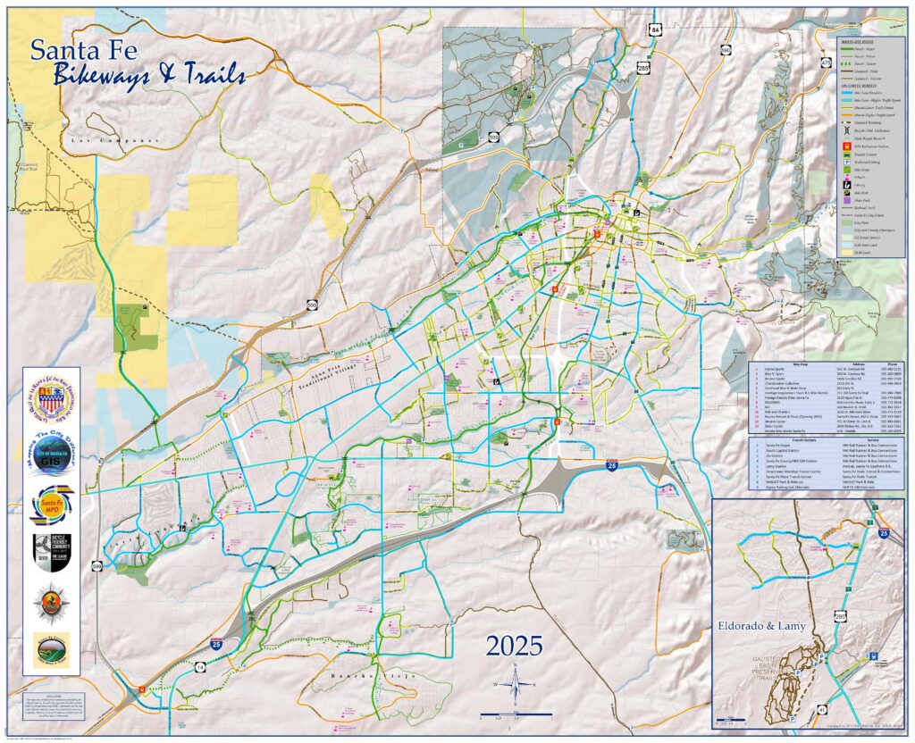
Bikeways & Trails Map
The Santa Fe MPO seeks to make bicycling a safer and more convenient form of everyday transportation for citizens and visitors.
2025 santa fe Bikeways and trails map
Clicking on a map will open a downloadable copy in a new window. These are large files and can be slow to load.
Printed copies of the map are available:
at the MPO Offices, City Hall (City Managers Office), Main, La Farge & Southside Libraries, all area bike shops, Santa Fe Community Convention Center, Santa Fe Visitor Information Centers, and at the Santa Fe Chamber of Commerce. The 2025 Bikeways and Trails Map can be viewed and downloaded on this page. See the links found on the trail map!
2025 santa fe Bikeways and trails map backside
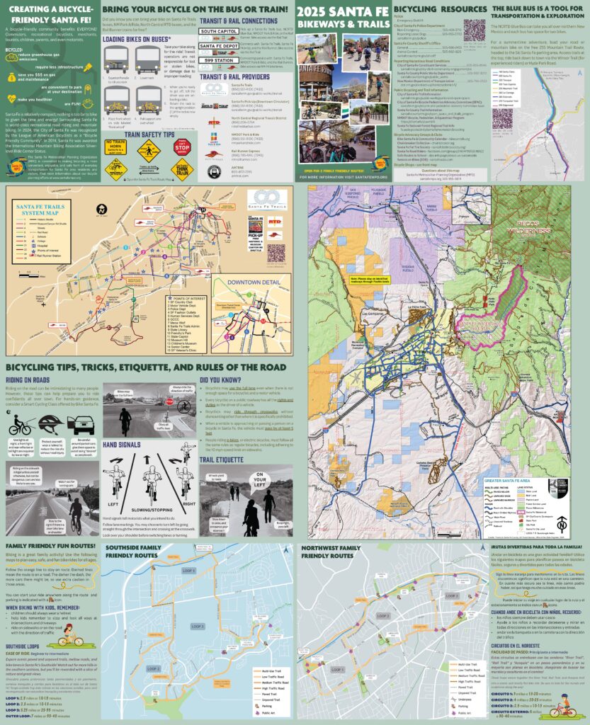
2025 santa fe Bikeways and trails map regional map insert

Hey Families: Check out these bike routes near you
These bike routes were thoughtfully put together to minimize traffic interactions and are a really good place to start biking with your kids!
Rutas divertidas Para toda la Familia!
Let us know your thoughts!
You can use facebook, or the Get-in-Touch Button at the top of the page to send us feedback about anything map or transportation related.
Notice:
Santa Fe County Interactive Trails Map
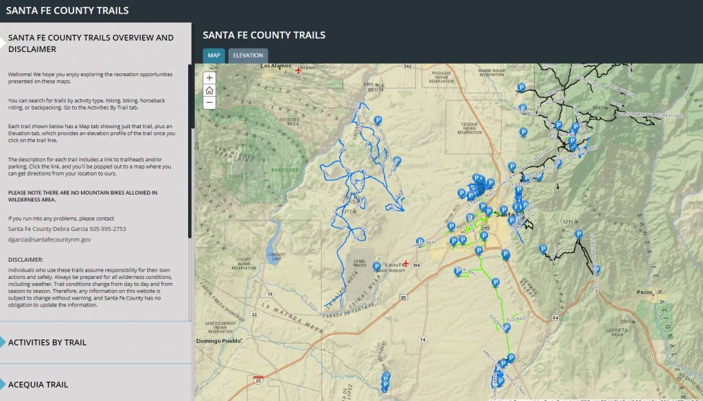
Santa Fe County has created an online, interactive trails map that is now available to the public! You can find hundreds of miles of trails throughout Santa Fe County, including County trails and Santa Fe National Forest, City of Santa Fe, and private land trails.
The map contains trail descriptions, elevation profiles, images, parking locations, and contact info. It allows users to search for trails based on user type (hiking, mountain biking, horseback riding, backpacking) and includes paved, soft surface single track, double track, trails and roads.
Click on the map image to go there! See the County information related to the map.
The Santa Fe Bikeways and Trails Map was created through public input to show the perceived suitability of on-street facilities for bicycling.
The conditions at specific locations are subjective, always changing, and may vary from what is shown on the map. Please use the map as a community-based guidance to help you select a bicycling route that meets your needs and skill level. Always use caution to evaluate the current roadway conditions.
The Santa Fe MPO seeks to make bicycling a safer and more convenient form of everyday transportation for citizens and visitors.
Santa Fe is an ideal bicycling environment due to its compact size, moderate terrain, and pleasant weather. A bicycle offers an alternative travel choice for those concerned about the environment, and requires relatively little infrastructure. In addition, bicycles can have travel times comparable with automobiles for short distances and are less expensive to own and operate than automobiles.
Past maps
To view or download past Bikeways and Trails Maps select the links below:
- Bikeways Map – 2021
- Bikeways Map – 2021 Backside
- Bikeways Map – 2018
- Bikeways Map -2018 Backside
- Bikeways and Trails Map – 2012 [6.5Mb in Size]
- Bikeways Information – 2012 [6.5Mb in Size]
- Bikeways and Trails Map – 2009 [1Mb in Size]
- Bikeways Information – 2009 [0.8Mb in Size]
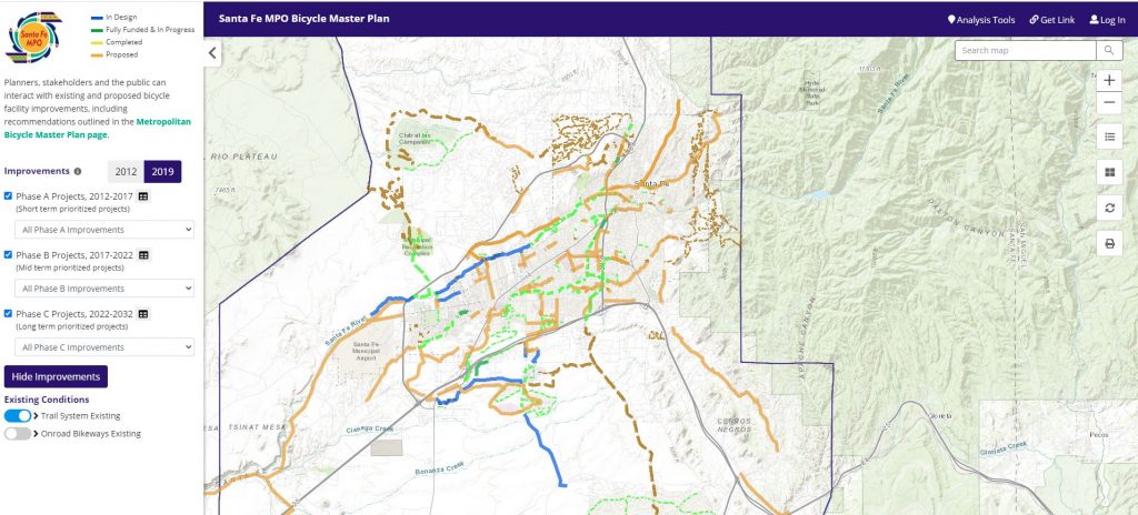
web-based mapping platform for the Bicycle Master Plan
Below is the dream for Santa Fe… what could exist for walkers and bikers with the right attention and funding. We are always interested in your ideas, Contact us if we are missing essential connections!
Click the arrows in the top left to view the legend and toggle on or off the layers. Click on each line for project details. Click on the link below this map to open it as a full window.
Scroll up to see the printed versions with the existing bikeroutes available free and distributed by bikeshops and recreation centers all over town.
Check out our Bicycle Master Plan Page for more infomation.
See our Bike/Pedestrian project MAP!
This map shows the envisioned pedestrian and bicycle projects found in the Bicycle Master Plan, Pedestrian Master Plan, and Metropolitan Transportation Plan. We are always taking comments on these, and value your observations and opinions. It is less updated than the map above, but has some phasing information in it.
To find out How to use the Bike/Pedestrian Projects map, see the pdf below
Help up to improve this page!
Are the maps taking too long? Please let us know what you would like to see in terms of functionality, and how you are using these maps. Send comments directly to [email protected], or get in touch with MPO staff another way!
Office Address
Monica Roybal Center
737 Agua Fria Street
Santa Fe, NM
View Map
Office Hours
8:00 am – 5:00 pm
Tuesday, Thursday, Friday
Virtually 8 -5 weekdays
(505) 955-666four
CONTACT US PRIVACY POLICY SUBSCRIBE
©2019 Santa Fe MPO | All Rights Reserved